Translate

Thursday, March 07, 2013

Death in Argaga, La Gomera, during storm March '13 +SPECTACULAR VIDEO of previous accident there

Will fences and more signs prevent accidents ?

The storm died down just as predicted and all modes of transport are operating normally again. All warnings and alerts have been lifted and the weather forecast is for lots of sunshine this weekend as high pressure is becoming established again.
Here in Valle Gran Rey there still is shock and disbelief after the death of a 26 years old German tourist (see updates 17 + 19 of Storm will affect Canary Islands (+ 21 updates) ) on Monday during the storm. The victim had attempted to walk to a ravine called Argaga with a friend when she was killed by falling rocks just after a very heavy squally shower. She had been warned and advised not to walk out there, but decided to risk it anyway in the face of the worst possible weather conditions and a red alert.
Let me explain about the extremely dangerous path they took:
Argaga is in the municpal area of Vallehermoso, but can only be reached by following a private dirt track from the harbour of Vueltas in Valle Gran Rey which follows the coastline for about half a mile below a several hundred feet high sheer cliff. This path is extremely dangerous even in the finest weather, as every now and again rockfalls do occur in this area and there are 3 huge signs plus another regular sign warning of the risk. In bad weather this path becomes a deadly trap. Some images taken yesterday will explain the location better (click to enlarge):

Warning sign even in English


Only about two weeks before this fatal accident there was another death caused by a minor rockfall in Playa de las Arenas, aka 'Schweinebucht' (see my post: Mother of two killed by minor rockfall on La Gomer...) .
My sincere condolences to all concerned.
Now let me stress that thousands and thousands have walked, cycled and driven out there  without any problems. There are three attractions in the Argaga ravine: 
First the 'Finca Argayall, which is a retreat and yoga centre operating like an alternative hotel (see: http://www.en.argayall.com ). Then there is a fruit farm where more than 160 varieties of fruit are cultivated and guided tours with fruit tastings are offered twice a week (see: http://fruchtgarten.com/ger/index.htm ) and the hippie caves at Playa de las Arenas, better known as 'Schweinebucht' , where the young mother died tragically two weeks ago. There are also about half a dozen private houses in Argaga and a banana plantation owned by an Englishman. The whole Argaga ravine is privately owned and also contains some demanding and dangerous hiking trails, which regularly see the rescue helicopter being called when inexperienced hikers attempt the ascent to the mountains from there.
Now the local administrations of V.G.R. and Vallehermoso want to close the track completely and erect fencing at the end of the harbour beach to prevent access and put up more signs. V.G.R. wants to spend 8000 (!!!) Euros on this project which to me sounds like they plan the erection of an 'iron curtain'.
The existing signage is loud and clear and whoever wants to risk walking out there is well aware of the danger. When you're under that sheer cliff and see fallen rocks and debris around you, you don't even need any signs to put 2+2 together ! Should every dangerous bend on a road that has caused fatalities, indeed all dangerous locations, be closed and fenced ? Accidents DO happen and humans DO take risks and will continue to do so no matter how safe the location.
A few years ago I made a personal decision not to use that track anymore when returning from Argaga I found a huge wedge of razor-sharp rock stuck a foot deep in the ground exactly between the imprints of my boots in the dust left from walking out there just an hour before....
Others had much narrower escapes as the video below illustrates (watch the white car !). It also shows what that track is like in heavy rain, and you can watch big lumps of rock crashing into the harbour:


The story behind the video:

Harry,the driver of the white car, had just finished work at the 'Finca Argayall' that day (Feb. 17th 2010) and could see bad weather rapidly closing in, but being tired after work wanted to make a dash for home. He knew that it was dangerous and also knew that if he din't make it home in a hurry that he might be stuck out there for hours, as it is often more dangerous AFTER the rain when loosened material heats up and expands in the sunshine.
What happened then is seen in the video, but what you don't see is that just before he reverses the car a lump of rock fell straight through the roof of the car, missing him by a couple of inches. The car was also scraping on fallen rocks on the ground and got stuck in the end. Harry scrambled out and escaped on foot, leaving a totally wrecked car.
I meet him directly after his miraculous escape in a local bar where he once had worked and where I was sheltering from the rain. He was as white as a sheet and badly in need of a stiff drink !
Very sadly, less than three years after the incident he died in his mid-forties at home on the sofa of a heart attack.


P.S.: While I was writing this post the rescue helicopter was circling the mountain behind my house once again. A local man put it to me a couple of days ago: ''The helicopter hardly ever has to come for one of the locals. Why don't the visitors stick to the hundreds of miles of SAFE walks and paths and why do they feel attracted to danger and go places we avoid in poor weather ? This is getting worse every year !''


Monday, March 04, 2013

Sunday, March 03, 2013

Storm in Canaries today and tomorrow


As this is a ongoing story, I have added today's updates to the main post - just click the following: Storm will affect Canary Islands

...or if you're on the HOME page just scroll down a bit
UPDATE March 7th: STORM IS GONE !

Saturday, March 02, 2013

Storm soon to hit Canary Islands


As this is a developing story, I have added today's updates to yesterday's post - just click the following: Storm will affect Canary Islands

...or if you're on the HOME page just scroll down a bit.
UPDATE March 7th: STORM IS GONE !

Friday, March 01, 2013

Storm will affect Canary Islands (+ 22 updates), March 2013

Due to a large blocking-high near Britain and Ireland the Atlantic low pressure systems are forced further south and a storm system is beginning to develop rapidly west of Madeira. It is expected to track east and reach a minimum pressure of about 974 hPa by Monday just north of the Canary Islands near Madeira.
This situation will bring unsettled rainy weather to the Canaries from today until the beginning of next week. The most worrying factors will be the winds and the state of the sea. Winds from a southerly direction will be strengthening gradually to veer west later this weekend and reach gale to strong gale force with stronger gusts particularly on exposed higher ground. Significant wave height (with the gales blowing over a heavy westerly swell) could reach more than 5 metres on exposed coasts. Some heavy spells of rain and thunderstorms (to a lesser extent) could also affect us.
Don't plan any hiking tours, etc. for Sunday, Monday, Tuesday - and avoid exposed coasts !

I will update this post regularly:

+1st UPDATE 01/03/13 @ 10:30 am: The Spanish met. service have issued the first weather warnings for for the western Canaries and Gran Canaria for Sunday 03-03-13 from 12noon: Very heavy and persistent showers with up to 30mm/hour and 100 mm in 12hrs, as well as  wind gusts of up to 100km/h (Bf: storm force 10), even up to 120 km/h in the mountains.

+2nd UPDATE 01/03/13 @ 7:30 pm: From Tuesday the weather should improve a lot, but will remain unsettled and windy - thankfully to a much lesser degree.

+3rd UPDATE 01/03/13 @ 8 pm: The Canarian Meteorological Association have issued a rare RED weather alert for the above situation. They emphasise the threat to coastal regions by waves of between 5 and 7 metres on exposed coasts in the western regions - and to exposed high ground by wind gusts of up to and above 120 km/h (that is around Force 12 Bf = hurricane force !). The situation will first affect the western regions in the Canaries and will then extend to the eastern islands. Very heavy showers can be expected almost anywhere.

Please do not expect extremes everywhere, but DO be careful and and DO take precautions - even if conditions appear to be pleasant for a while !!!

+4th UPDATE Saturday O2/03/13 @ 00:30 am: 
Here's a general synopsis of the situation right now superimposed on a recent satellite picture which was published by Jose Luis of ACANMET in their forum. I've just changed some of the text annotation to English and put  a light green oval around the Canary Islands. The white text over the yellow arrow says: ''In 36 hours we'll have it (the storm) near the archipelago''. It illustrates the disturbed weather very well. Thanks and a great job, Jose Luis!


+5th UPDATE Saturday 02/03/13 @ 9:30 am:
New additional severe weather warnings have just been issued by the Spanish met. office AEMET for all  day Monday, 5th of March '13: 
Coasts will be affected by heavy seas with waves of up to 5 metres.
Winds could reach 100 km/h or more.
Heavy showers can be expected.

+6th UPDATE Saturday 02/03/13 @ 1:30 pm: 
The government of the Canary Islands has issued a severe weather alert which comes into effect from 9am on Sunday 3rd of March '13:
 People are advised to avoid unnecessary journeys and to stay away from exposed coasts, ravines, forests, power and phone lines, etc., and to secure garden furniture,scaffolding, etc.. Some sporting fixtures and open air events have already been cancelled.


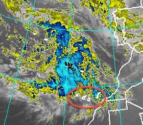
Satelite image @ 6am, with 'Funktop'
 enhancemnt (Canaries in red oval)
+7th UPDATE, Sunday 03/03/13 @ 9am:


The day is starting completely overcast and after a calm night the wind is slowly increasing and turning gusty.
All emergency services in the Canary Islands have been put on standby and the authorities have asked the population and visitors to remain indoors and not to travel unless absolutely necessary. They're also advising to take the maximum care and all possible precautionary measures.


+8th UPDATE, Sunday 03/03/13 @ 10:30am:
The latest wind warnings by AEMET have increased maximum winds speeds to 120 km/h - that is Bf hurricane force 12  - for gusts in exposed areas in the western islands.
The storm system is moving in from the West and so the Eastern Canary Islands will be affected last and (hopefully) to a lesser degree.

If you have to travel later today or tomorrow, do be extremely careful and allow extra time. My personal opinion is that all traffic by road, sea and air could be severely disrupted from later today until Tuesday - and especially tomorrow, Monday March 4th. Expect cancellations and check with the operators of whatever service you're planning to use.


+9th UPDATE, Sunday 03/03/13 @ 4:30 pm: 

The government of the Canary Islands has declared the highest alert level (ALERTA MAXIMA) for the western Canaries and for Gran Canaria. They now expect winds gusting well above hurricane force 12 Bf with speeds possibly exceeding 130 km/h in places. 

A press conference is expected to be held shortly.

It certainly is gradually getting worse by the hour and I'm just back from securing everything I could around two presently vacant neighbouring houses as well. It looks like tonight is going to be a long sleepless night. I just hope the power supply and the phone lines will hold. If you don't hear from me every now and again you'll know that they didn't hold. 
I'll give you details of the press conference later...

+10th UPDATE, Sunday 03/03/13 @ 6:30 pm:
Not much new at the press conference. I've already reported all the relevant information in my previous updates. The only news was that all schools and universities in La Gomera, La Palma, El Hierro, Tenerife and Gran Canaria (all the islands that will bear the initial brunt of the storm) will remain closed tomorrow.
Some minor incidents and traffic disruptions have already been reported from western islands. 
The winds here in Valle Gran Rey on La Gomera have risen to a gale by now and the barometer keeps falling rapidly. The sea is very angry-looking and it is beginning to rain lightly. There was heavy rain in La Palma already and more than 100 mm have been reported at one station there.

+11th UPDATE, Sunday 03/03/13 @ 9 pm:
There are reports of road closures in the western Canaries and the last ferries to leave La Gomera were unable to berth in the port of Los Cristianos on Tenerife due to the strong wind and some waves coming in over the harbour wall. They will probably now continue to Santa Cruz de Tenerife. The Fred. Olsen ferry to La Palma was unable to dock there and is now going back to Tenerife. My guess is that there won't be ANY sailings anywhere in the Canaries tomorrow, but DO check with your ferry company. Some flights in the second half of today were cancelled or diverted, but most did operate.
There was some flooding on La Palma and very strong winds up to 140 km/h and an articulated truck was overturned by the storm.
Reports of thunderstorms, heavy rain and winds well over 100 km/h are coming in from Tenerife and parts of Gran Canaria.
Here in Valle Gran Rey on La Gomera some stretches of road have been closed due to flooding of the barranco, as it has been raining continuously for a good while now, and some of that rain has been extremely heavy, accompanied by strong gusts of wind. As I write the rain is stopping, however.
Rockfalls and landslides have caused road closures and traffic restrictions in several locations in the western islands.
Ah yes, the Canarian meteorological association have named the storm 'Arteara' (after a place on Gran Canaria). It is their third named storm this winter season and the most vicious by far.
... and they say Arteara's worst wind is yet to come.


+12th UPDATE  Monday 04/03/13 @ 1 am:
GFS forecast model for 12 noon Monday,
March 4th '13, (Canaries in red oval)
Last night's sailing by Fred. Olsen's huge trimaran car ferry from Gran Canaria to Tenerife hit some very large waves that caused the boat to roll so heavily that many cars on the car deck were pushed into each other and badly damaged. The ferry port of Agaete on Gran Canaria has now been closed as has the important ferry port of Los Cristianos on Tenerife, the port of Santa Cruz de La Palma, the ferry port of El Hierro and the port of San Sebastian de La Gomera. All this leaves most of us in the Canaries cut off from each other (and from vital supplies),and lots of travellers are stranded.
There were many minor incidents, small scale power cuts, localised flooding and blocked stretches of road reported from around the archipelago. On the island of El Hierro a several hundred year old dragon tree (an emblematic tree in the Canaries) sadly was felled by the gales.
Madeira has also been severely affected by the storm as has Morocco.

After a couple of hours of relative calm in Valle Gran Rey on La Gomera the wind is beginning to increase again and has backed SW...


+13th UPDATE, Monday 04/03/13 @ 3:30 am:


Significant wave height in metres for noon,Tuesday
 March 5th '13 (OPC) Tenerife is shown in the red circle
Sleepless night as predicted - I'm just too excited by this event and have been through this many a night in the West of Ireland when it was even worse and you didn't know if the roof would stay on.
Anyway the wind is rising rapidly again, the barometer is falling rapidly again and a short shower of rain is lashing not down, but sideways again !
The highest wind gust last night was recorded in Valverde, on El Hierro, by the official AEMET station, clocking a whopping 154 km/h (that's 96 mp/h to you, or 83 knots to me) ! Tenerife got the second-strogest gust at Izaña (140 km/h), 3rd place went to Gran Canaria (Tejeda,131 km/h) and La Gomera came fourth with 125 km/h recorded at Alto de Igualero, followed with just 1km/h less by the airport of La Palma - all well over the starting line for hurricane force.
The main worry over the next 18 hours should be the wind, and over the coming 36 hrs it's the significant wave height, which is increasing gradually with wind over a heavy swell.


+14th UPDATE, Monday 04/03/13 @ 8 am:

No change - ALL WARNINGS REMAIN 'IN FORCE' FOR TODAY.
Image taken a few minutes ago, with waves in front of Hotel Gran Rey on La Gomera.
Wave height is expected to increase significantly until tomorrow.

+15th UPDATE, Monday 04/03/13 @ 9 am:
AEMET, the Spanish met. office have now issued their highest (RED) alert, as well as the Canarian ACM, for all of La Gomera and El Hierro plus for the mountains of Tenerife, La Palma and Gran Canaria. 
Winds exceeding speeds of 130 km/h in gusts can be expected there and the danger is IMMINENT, but more likely from around 11am.
Lesser, but still very significant danger exists in all other regions of the Canary Islands and further alerts for more areas may be issued later.
For detailed information go to the AEMET website by clicking the following link:              
http://www.aemet.es/en/eltiempo/prediccion/avisos?w=hoy&k=coo&datos=img


+16th UPDATE, Monday 04/03/13 @ 1 pm:

At about 11:30am we had an extremely heavy squally shower  that caused waterfalls in the steep mountainsides in Valle Gran Rey - and the electricity went until short while ago. The blustery squall itself didn't last too long, but as I write the next one is approaching rapidly. The temperature has dropped considerably with the first one and that means that the cold front associated with the storm depression is near or on us. It is a similar situation all over the Canaries and the coming hours should be interesting...
The only ferry now connecting La Gomera to the outside world is the ship of the Armas line that is sailing from Santa Cruz de Tenerife (instead of Los Cristianos) at the moment in the hope of berthing in San Sebastian de La Gomera and then attempting the return to Tenerife - weather permitting, that is !  The Fred. Olsen line have said that sailings are 'hardly probable' which I interpret as 'forget it'. 
As I was writing the last words, the latest squall knocked out the power again for 10 mins. so I'll better finish this quickly.
All over the Canaries now: Traffic (sea, air, road) disruption - but not too bad. Lots of minor incidents and accidents. A larger landslide/ rockfall blocking the  minor road to two small villages here on La Gomera. 
BUT THANKFULLY THERE WERE NO REPORTS OF CASUALTIES UP TO NOW.
ALL WARNINGS REMAIN UNTIL BEING REVISED.


+17th UPDATE, Monday 04/03/13 @ 4:30 pm:
...well unfortunately we now have a casualty here in Valle Gran Rey. One person was very seriously injured by a rockfall. I won't say any more  - ONLY TO STRESS AGAIN THAT IT IS EXTREMELY DANGEROUS TO BE OUT AND ABOUT IN THIS WEATHER. Don't be deceived by short periods of sunshine and slacker winds. Only venture out when necessary and then with extreme caution.
Since my last post it has been raining almost continuously, interspersed with very heavy squalls with fierce gusts of wind and, of course, power outages of various duration. The barranco, a normally dry riverbed, is like a river in spate now. The weather is still worsening and the waves are getting larger and more organised all the time. 
Police and ambulances are racing with sirens blaring again just now, but I don't know what happened.

The MAXIMUM ALERT declared by the government has been extended to     !!!!!!!!!!!!       ALL CANARY ISLANDS now.                          

Huge area of thunderstorms very close to Canaries now


+18th UPDATE, Monday 04/03/13 @ 7 pm:
OPC chart promising better weather in Canary Islands
(in red oval) for Wednesday, March 6th 2013
Some light at the end of the (wind)tunnel at last: Most forecast models have changed and it seems likely that from later tomorrow, Tuesday, the storm system will have begun to fill and move away and this will allow for a ridge of high pressure to move in over the Canary Islands on Wednesday, bringing much better weather.
However, warnings and alerts will remain in effect for tomorrow, Tuesday 5th of March (albeit downgraded a bit).
Wind, waves and occasional squally showers may still reach dangerous levels in the first half of tomorrow.

+The previous warnings for tonight remain ! There is the additional risk of thunderstorms, which could strike anywhere in the archipelago tonight.

The Fred Olsen ferry company has cancelled all sailings today until further notice and the planned sailing tonight by Armas from Gomera to Tenerife has been cancelled, as have many inter island flights. This situation will be revised tomorrow. As I write another severe squall is buffeting the house and a thunderstorm is lurking just west.


+19th UPDATE, Monday 04/03/13 @ 10 pm:
Sadly the casualty mentioned in my 17th update has now died of her severe injuries at the university hospital on Tenerife. She was a 26 year old German tourist who had been walking along a dirt track below a very tall sheer cliff leading from the harbour of Valle Gran Rey to a remote place called Argaga, when she was struck by falling rocks. She was rescued promptly by two different units of the emergency services and transferred later by helicopter-ambulance to Tenerife - all in atrocious weather conditions. She is the only fatality during storm 'Arteara' in the Canary Islands.
Meanwhile 'Arteara' shows no signs of easing at all and is still roaring wildly.
I'll leave it at that for today. 


+20th UPDATE, Tuesday 05/03/13 @ 9 am:              

Gust (km/h)
Station
Province
Hour
km/h
 Tenerife
00:10
174
El Hierro
14:10
140
La Gomera
00:20
131
Gran Canaria
13:20
121
Tenerife
15:30
121
   Click on stations to get detailed reports

Last night the storm peaked with severe gusts reported everywhere in the Canary Islands. As you can see above, the AEMET stations recorded a 131 km/h near Igualero on La Gomera yesterday, less than 15 miles from where I live and last night gust  they recorded nearly the same. There were heavy downpours of rain in many locations as well and some thunderstorms. It certainly was the peak of the storm where I live in Valle Gran Rey and my house was pummelled all night by severe gusts and  repeatedly very heavy showers pelted the roof.
All in all the Canary Islands escaped relatively unharmed after being battered by a very rare continuous storm that lasted more than 50 hours.
Schools and colleges have re-opened today
Warnings and alerts will remain in effect for today, Tuesday 5th of March 2013 until further notice.
At the moment winds are still strong and gusty, but decreasing, and the heavy swell is still causing problems for maritime traffic. Hundreds of people are stranded in the port of Los Cristianos on Tenerife because ferries were unable to berth. The Armas ferry that tied up in the port of San Sebastian de la Gomera yesterday was forced to leave for Santa Cruz de Tenerife during the night due to heavy seas entering the harbour. Several stretches of coastal roads have been closed, e.g. here in V.G.R. the stretch between La Playa and La Puntilla, due to waves breaking over the protective wall.
THE OUTLOOK:
Conditions should improve substantially later in the day as winds will gradually ease and the squally showers will become less frequent. The heavy swell at sea will slowly decrease from tonight. Lots of sunny spells, too. I expect warnings and alerts to be lifted later in the day, but please remain cautious today.
High tide is around 7pm tonight in the Canaries.
Tomorrow should see a return to more 'normal' Canary Islands weather.

+News just in: Fred. Olsen ferries will resume all sailings.
To La Gomera the following revised timetable applies today only (delays are possible, though):

Gomera - Cristianos 10:00 Horas
Gomera - Cristianos 12:00 Horas
Gomera - Cristianos 17:30 Horas
Cristianos - Gomera 09:00 Horas
Cristianos - Gomera 11:00 Horas
Cristianos - Gomera 14:00 Horas
Cristianos - Gomera 19:00 Horas


+21st UPDATE, Tuesday 05/03/13 @ 2 pm:  

Conditions are gradually improving, but during the occasional squalls it is still quite wild. News just in: There have been several larger rockfalls and/or mudslides on La Gomera, forcing the temporary closure of some stretches of road (e.g. Alajero - Pajarito and the road to El Rejo between the junction near Agando and the branch-off to El Cedro). Crews are out clearing the debris and it is hoped that these roads will reopen later today. 
The authorities are reminding motorists and pedestrians to remain extremely cautious  on roads and paths. 
The danger from rocks and soil loosened by  storms and/or heavy rains is often greater after the event when the sun is shining on the unstable material.
The threat to coastal regions remains until at least tomorrow morning as it will take quite some time for this swell to subside (the photo below was taken just a while ago of an average wave in front of Hotel Gran Rey at around LOW tide - CAUTION: High tide is around 7 pm tonight !):
Storm in Canary Islands, March 5th, 2013

22nd UPDATE, Tuesday 05/03/13 @ 10:30 pm:  


All's well that ends well - and thanks for the rain...
Just now the situation is calm and there aren't any more squalls, gusts,showers, high waves... 

THE STORM IS OVER!!! 

Back to normal tomorrow with CAUTION after a rare event. REMAIN VIGILANT TONIGHT AND TOMORROW MORNING!
 

+++++ SOME MORE WEATHER CHARTS:


OPC Chart for Tuesday March 5th showing the 'retreat' of the lows
and building high pressure to the South of the Canary Islands


OPC chart valid noon Sunday showing storm and new low forming


NOAA chart for Saturday night, March 2nd '13
NOAA chart for noon on Monday, March 4th, 2013

Significant wave height for Tues. March 5th at noon.The small red
arrow points to La Gomera and Tenerife being on the 6 metre line.
UPDATE March 7th: STORM IS GONE !

Thursday, February 28, 2013

More fruit trees for fire victims

La Gomera's government will distribute more than 2.300 fruit trees for immediate planting to farmers and residents who lost crops and trees during the devastating fire last summer. The trees will be distributed in the town of Chipude from 11am today, and will cosist of 15 varieties, including apple, almond, cherry, plum, peach, etc..
In several separate distributions in Valle Gran Rey nearly 1500 tropical fruit trees have already been distributed and planted.
More fruit trees will be given away in several locations soon and the total number re-planted will reach well over 5.000 .
UPDATE 8pm: Further goods news today is the ministry for environment's allocation of nearly 580.000 Euros for the repair of damage in La Gomera's forest 

Wednesday, February 27, 2013

Rhythm and Dance Show comes to La Gomera

UPDATE 02-03-'13 @ 11pm: 
I'm just back from the performance in San Sebastian and let me tell you that it was one of the best shows I've ever seen ! Highly professional and very entertaining, and the stage set, lighting and sound deserve to be mentioned too. 'Cambyuon' got a standing ovation on La Gomera, even though Gomerans are very slow to clap their hands any more than politeness demands ! My hands are still sore anyway, as the ovation continued in the rhythm of the encore and long after that.
Don't miss 'Cambuyon' if they perform anywhere near you in the future.

Monday, February 25, 2013

World's largest yacht visits La Gomera

...or is it a cruise ship ? Well, judge for yourself. It is the MS 'The World', which is a bit like a cruise ship, but the 165 suites are privately owned residences. The owners - when aboard - decide on the itinerary by holding a ballot and the vessel travels all year round to wherever the owners decide to go. The ship is often called 'the cruise ship of the millionaires' and the accommodation is referred to as a 'residensea'. The 644 feet long vessel today anchored off La Gomera (for security reasons, I suppose) and the presently just over 100 owners and guests aboard are being ferried ashore and back by the ship's own water taxis.
More info and a glimpse of life aboard here:http://aboardtheworld.com/our_story
MS THE WORLD  ©www.list.at

Sunday, February 24, 2013

Special offer extended by ferry company

'Naviera Armas', the Canary Islands ferry company, have extended their special offer for all inter-island ferry connections until the 21st of March. Residents can travel for just 7 Euros and tourists for only 14 Euros per trip, and the price for a car is the same as for a passenger.
Meanwhile their competitor 'Fred Olsen Express' have a limited offer of tickets for the same price which ends on Feb. 28th.
To view these offers just click on the relevant link on the sidebar.
UPDATE:
Summer 2013 - while the extremely low prices are no longer available, some very attractively low fares are still available on select dates. Keep checking both ferry companies.

Saturday, February 23, 2013

Carnival Photo Slideshow

Some impressions taken during and after yesterdays carnival parade in Valle Gran Rey, La Gomera. Today the carnival here ends  with the 'funeral of the sardine', which is again followed by dancing to two major salsa bands until the early hours of the morning...


Monday, February 18, 2013

Longevity on La Gomera

In the small town of Agulo on the north-side of La Gomera there were two great celebrations recently: First the 70th wedding anniversary of a happy couple, both partners being 92 years old.
Today it was the 104th (!) birthday of María García Henríquez who is said to be in good health and looking forward to her 105th !
People really do seem to live longer on La Gomera.
UPDATE 22-02-13: Today it is the 100th birthday of Adelaida Aguilar Darias in San Sebastian de la Gomera. Congratulations !

Saturday, February 16, 2013

Mother of two killed by minor rockfall on La Gomera

A 30-year-old mother  was killed early this morning by a few rocks that fell from an overhang under which she was sleeping with her two youngest children. The rocks fell only a few feet but directly on top of her and the emergency services found her dead when they arrived on the scene. On of her children received minor injuries while the other escaped unharmed. The victim was of German nationality.
The incident took place in an area that is locally known as 'Playa de las Arenas', but better known as 'Schweinebucht' which is German for 'Bay of Pigs'. Access to the area is extremely difficult to gain, particularly at high tide. It has been a popular place with hippies since the 60's and the caves in the bay  house a hippy encampment to this day.
UPDATE 17-02-13: The initial press reports contained some errors: The victim wasn't 30, but in her late thirties and she has at least two more children at home in Germany. She was a regular visitor to La Gomera and had spent some time at the scene of the accident when she was about 19. She was well known and liked locally.
In the red oval the location where the mother of two was killed in her sleep. The fallen rocks can be clearly seen, as can the gaps they left in the rockface (whitish colour).    Photo ©gomeranoticias.com

Friday, February 15, 2013

Transatlantic solo rower set to break world record

See also latest UPDATE: New Transatlantic World Record !

Charlie Pitcher is well underway to break the Transatlantic solo rowing world record. In his attempt he will have to row the 3000 nautical miles from La Gomera to Barbados in less than 40 days. 
He initially set out from the port of San Sebastian de La Gomera on Feb. 2nd but decided to turn back after six hours of battling strong currents and headwinds. He finally left port
on Feb.6th when conditions were much more favourable. By now he has already covered more than one fifth of the distance and has at times reached speeds of over 14 knots when surfing waves. Charlie is hoping to raise funds for charities in his daring attempt.
You can find out more and follow his progress on his website:http://transatlanticsolo.com/home/
Here's a video of Charlie Pitcher on his boat in La Gomera:


Monday, February 11, 2013

Five crew die on cruise ship 'Thomson Majesty'

During a routine emergency-training exercise aboard the cruise ship 'Majesty', which is visiting the port of Santa Cruz on the neighbouring island of La Palma, five crew members have lost their lives on Sunday, Feb. 10th 2013. A further three crew were injured.
The life-boat fell from a great hight after one of warps parted as the boat was being launched from the davits and the second warp then broke as well due to the heavily swinging weight. The boat crashed into the harbour causing the death of four crew initially and a fifth died a while later after having been rescued by the local life boat which also managed to save the lives of the remaining three crew.
The 'Thomson Majesty' had arrived from Gran Canaria the same morning at 8am with about 1500 mostly British passengers (plus about 500 crew) and was due to proceed to the island of Madeira later that same day. She will have to remain in the port of Santa Cruz on La Palma until the investigations are concluded.
Since the sinking of the 'Costa Concordia' in Italy all cruise ships are carrying out emergency drills in every port they visit.
UPDATE 25-02-13: The 'Majesty' is now back to 'business a usual' after extensive safety checks. 
The life-boat that crashed can be seen capsized on the right (white keel, in front of open hatch) Photo © Marcos J. Rodríguez /elmundo.es
...and here's a BBC news video with more details:

Friday, February 08, 2013

Carnival in Canary Islands

It's carnival time in the Canary Islands and this is a huge event that doesn't exactly keep to the traditional carnival timetable. It goes on well after Ash Wednesday, even getting close to Easter some years, as each community stages their own and wants participants from neighbouring towns. The main events are in Las Palmas on Gran Canaria and in Santa Cruz on Tenerife, the latter being the second-largest carnival in the world after Rio de Janeiro. In Santa Cruz this year some events have been cancelled because during the election gala for the carnival queen one of the contestants' elaborate costume caught fire and she was severely burnt.
But wherever you'll be in the Canaries over the next few weeks watch out for local posters and announcements. The actual parades and main events couldn't be missed anyway - the sights and sounds are obvious.
Each community end their festivities with the 'funeral of the sardine' when a large papier-mache sardine full of pyrotechnics  is burnt and pushed into the sea, accompanied by the wailing of 'grieving ladies', i.e. men dressed in women's black clothes.
Images from my archive of the carnival in...
...Valle Gran Rey, La Gomera in 2007

Tuesday, February 05, 2013

Calima: Weather from the Sahara

The much dreaded 'calima' weather  occurs when there is an easterly stream of air coming from the Sahara desert bringing with it a cloud of fine, flour-like dust and sand and sometimes even locusts. It is often associated with easterly gales and hot dry air from the Sahara. In winter it is not too hot because at this time of the year the desert is cooler, but in summer it can feel like a blast from an open oven. The air also becomes extremely dry and can cause breathing difficulties, dry mucous membranes, eye irritation and flu-like symptoms. The sun becomes obscured to appear like a milky disk and visibility is greatly reduced. Dust from the Sahara has on some occasions even reached Northern Europe, including Britain and Ireland, depositing yellowish dust on cars, etc..
In the Canaries the worst affected areas are usually the regions in between 1500 and 3000 feet of altitude, where it can become oppressively hot, while the lower regions benefit from a cooling effect by the Atlantic, which also supplies some moisture. The Eastern Canaries are generally more at risk. On La Gomera the phenomenon usually lasts only 2-5 days and is often followed by a shower of rain which clears the air but leaves a grimy deposit everywhere. 
The following saying is true for the Canary Islands, too: ‘When the wind is from the east, 'tis neither good for man nor beast’.
More details on the Saharan air layer

+Here's the official advice for Calima weather conditions and heat waves:

  • Carry water with you, and drink it often ! Still water is best.
  • Stay in the shade and places protected from the sun  as much as possible and/or stay cool indoors.
  • You can go for a refreshing swim, but make sure to slowly adjust to the water temperature
  • During daylight hours lower window blinds and/or close curtains and shutters.
  • Open the windows of the house at night to keep cool.
  • Use air conditioning or fans to cool the atmosphere - if unavailable, hang wet towels indoors.
  • Avoid dramatic temperature variations when entering or leaving places. Adjust gradually.
  • On the street avoid direct sunlight. Wear a cap or a hat, wear lightweight, light-colour clothing made of natural fibres, i.e. cotton.
  • Try to walk in the shade, be under an umbrella on the beach and rest frequently in a cool place.
  • Never leave children,  elderly,  pets inside a closed vehicle. 
  • Avoid prolonged physical exercise .
  • Take regular light meals,  drinks and foods rich in water and mineral salts, such as fruits and vegetables. They will help to keep you hydrated and replace the salt lost through sweating.
  • Avoid alcohol and very hot foods as well as high-calorie foods.
  • Help others. If you know of sick or elderly people living alone go to visit them regularly.
  • If you take medication, ask your doctor if it can affect thermoregulation or whether to adjust or change.

Saharan dust over Canary Islands (2004) ©earthobservatory.nasa.gov 
Normal visibility Valle Gran Rey, La Gomera
Visibility during a fairly heavy spell of CALIMA (taken Feb. 5th,2013)