News, Views, Info,Weather, and more about the hidden gem La Gomera, and the Canary Islands. Ads-free. INDEPENDENT.
Wednesday, June 07, 2023
Warning of heavy rains in western Canary Islands
Saturday, September 24, 2022
Storm Hermine: Heavy rain in Canaries - WARNING
A tropical storm named Hermine has formed north of the Cabo Verde Islands and is moving slowly north towards the Canary Islands. The associated heavy rainfall is imminent in the Canaries and warnings have been issued by the Spanish authorities for today, Sept. 24th 2022, tomorrow, and Monday. The American National Hurricane Centre has also issued a public advisory in its latest bulletin:
BULLETIN Tropical Storm Hermine Advisory Number 4 NWS National Hurricane Center Miami FL AL102022 800 AM CVT Sat Sep 24 2022 ...HEAVY RAINS EXPECTED THROUGH THE WEEKEND FOR THE CANARY ISLANDS... ...FLASH FLOODING POSSIBLE IN HIGHER ELEVATIONS...
HAZARDS AFFECTING LAND ---------------------- RAINFALL: Tropical Storm Hermine is expected to produce 3 to 6 (75 to 150 mm) inches of rainfall with localized higher amounts up to 10 inches (250 mm) across the Canary Islands through this weekend. This rainfall may cause some flash flooding in areas of higher terrain.
These rainfall amounts are especially hazardous after years of drought in the Canaries. Rockfalls and landslides can be expected. Do not walk or drive in the mountains. The Canarian government has issued the a ''maximum alert'' and recommends to avoid all travel and all outdoor activities. Traffic disruption is to be expected. All events have been cancelled. Flooding in valleys and all lower regions is also possible. Thunderstorms have been predicted which can deposit extreme amounts of precipitation in a short space of time. The western Canary Islands are most at risk and for these level orange warnings have been issued for La Gomera (even red for parts of La Palma island and same for all of El Hierro island), as well as numerous public advisories by local authorities. Rainfall may accumulate up to 30mm in just one hour in La Gomera
One bit of good news is that winds won't be extreme, but still an added hazard with warnings in place of peak gusts of around 70 km/h, but possibly higher in exposed mountain areas.
Below is a summary of the warnings issued for tomorrow, Sunday 25th of Sept. 2022:
Friday, October 12, 2018
Hurricane Leslie: will it affect Canary Islands ? Updated
![]() |
| Hurricane Leslie yesterday evening with the Canary Islands and the Moroccan coastline on the right |
UPDATE edited 10:30 pm, Oct.12th 2018:
The latest model runs all predict that Leslie will pass the Canary Islands much further to the north (see latest graphics below to compare with the earlier one above) and instead of having an impact here will instead affect the Iberian peninsula. Below a quote from the latest bulletin of the NHC in Florida:
''...Leslie is moving quickly east-northeastward on the southern side of a powerful longwave
trough centered over the north Atlantic. The track forecast reasoning has changed since the last advisory, with the GFS, ECMWF, and now the 06Z run of the UKMET all showing a more eastward motion of Leslie toward the Iberian Peninsula as the cyclone is picked u by the aforementioned trough. The new NHC track forecast has been adjusted significantly to the north and east, especially beyond 24 hours...
...Key Messages:
1. Leslie is expected to bring near hurricane-force winds on Saturday to portions of Portugal as a powerful post-tropical cyclone. Tropical-storm-force winds are also likely to affect portions of western Spain.
2. Leslie is expected to produce rainfall amounts of 25 to 75 mm (1 to 3 inches) with isolated amounts as high as 100 mm (4 inches) across portions of Portugal and Spain, which could cause flash flooding. ...''
Monday, February 26, 2018
Roads during poor weather
![]() |
| Minor road blocked by fallen rocks yesterday (Image: gomeranotias.com) |
Sunday, February 25, 2018
Finally some decent rain, beautiful rain
![]() |
| ...and lots of it today! (Image source: Twitter Proteccion Civil LG) |
![]() |
| Barranco of VGR beginning to flow |
![]() |
| Barranco of San Sebastian de La Gomera this afternoon (Image: RTVC.es) |
Corriendo también el barranco de Santiago en #Alajeró.— Protección Civil La Gomera (@PC_LAGOMERA) February 25, 2018
Recuerda: Evita acercarte a los márgenes de los cauces. pic.twitter.com/XO0ZlFJunu
Lunar halo - sign of coming storm ?
![]() |
| Briefly visible lunar halo - no time to change to 'good' camera and lens (Image taken 23:15 pm last night) Severe weather warnings for today Sunday Feb. 25th 2018: Check latest weather updates now |
Saturday, February 24, 2018
Half sunny, half rainy
![]() |
| Half sunny and half rainy this morning |
Friday, February 23, 2018
Waterspout missing boats and entering harbour
Impressive waterspouts hit La Gomera
#FMACanarias— Protección Civil La Gomera (@PC_LAGOMERA) February 23, 2018
Nos hacen llegar este vídeo desde Playa Santiago en #Alajero, donde se observan mangas de agua grabadas hace escasos minutos. pic.twitter.com/onN28CLhEL


Thursday, February 22, 2018
Adios 22-2
![]() |
| ''Adios al dia 22-2'' Sunset tonight with signs of 'incoming' weather. See previous post (click) |
A very rainy weekend in store for Canary Islands +
![]() |
| The Atlantic depression to the WNW of the Canary Islands at 9am UTC this morning |
An Atlantic depression of 999hPa now to the northwest of the Canary Islands is expected to track south and deepen a little, passing to the west of the Canaries tomorrow, before dissipating close to these islands early on Saturday. I won't bore you with all the details of the current weather situation, but here's what it means:
All below updated:
Sunday February 25th 2018:
Sunday morning: This low of 991 hPa has fully formed to the NNW as expected and will be N of us all of today with 992hPa. The associated cold front will pass over the Canary Islands during Sunday daytime from W to E. See warnings below
Rainfall up to 100mm in 12 hours
Canarian government has declared highest alert status 'ALERTA MAXIMA'
Renewed risk of thunderstorms.
Sunday's summary (Click)
Opinion:
To be honest, there have been alerts, warnings and advisories in recent times and then nothing much happened or the situation changed completely in no time at all, leaving disgruntled faces questioning the wisdom of the 'weathermen', meteorologists and officials. However, please bear in mind that weather forecasting in the Canary Islands is tricky and local conditions may vary drastically within a small radius. I've seen damaging floods and evacuations (eg. Playa de Santiago late 2013) when less than ten miles away people had 'a fine day'. So, I feel it is better to be warned when nothing happens thereafter than to get a nasty surprise. The current situation has, but doesn't have to have, some interesting potential anyway, and should not be under-estimated. In the age of weather apps that give you the slightly modified outdated weather for an airport on Tenerife when you look up the weather for any town on La Gomera (check it in depth, but sadly this is true - and it even fools most people in most weather situations) you're better off to be prepared for some severe weather now.
Isn't this a cleverly construed disclaimer so you can't blame me in case the weather gods don't deliver the 'bad' weather the locals are praying for? ☔ Want more ? Here we go...
Next week:
Southwesterly winds gusting 80 km/h
First half of Monday should see further heavy showers, some squally, but weather gradually improving during second half of the day while a chance of a few showers will remain throughout the day. Winds gradually easing but remaining fresh to strong.
UPDATE Sun.: This new major storm depression has begun to form and is expected 962 hPa in mid Atlantic soon with hurricane force winds near centre, then expected to track SE, later E to reach sea area just W of Azores by noon Monday as a storm of 967 hPa, slowly moving E of Azores as a vigorous depression of 975 hPa on Tuesday, with the associated wide-sweeping cold front forecast to affect Canary Islands later Tuesday and on Wednesday with potentially very strong winds and a band of heavy precipitation . A first warning of SW winds gusting 75 km/h has been issued, valid from 6pm Tuesday.
More late on Monday in a new post. A link to same will be added to the end of this post...
Generally:
https://lagomera1.blogspot.com.es/2018/02/another-cold-front-to-come.html
![]() |
| Lunar halo, caused by ice crystals and often associated with a coming storm (image taken 23:15 pm Sat. February 24th 2018) |
Tuesday, March 04, 2014
Warning of big swell and gusty winds
![]() |
| Bay of Hermigua on La Gomera's north coast |
Monday, December 02, 2013
Warnings and alerts for extremely heavy rain and thunderstorms
Several minor roads and La Gomera's airport have been closed.
![]() |
| Thunderstorms moving W to E at midday 02-12-13 |
![]() |
| Source: gomeranoticias.com |
The situation has improved and there is some sunshine now in Valle Gran Rey.
Alerts and warnings for La Gomera will remain active until tomorrow morning 9am.
Giumar on Tenerife was one of the worst-affected areas with more than 180mm of rain this afternoon. Here's a frightening video from the area:
Monday, March 04, 2013
High winds and high seas in Canary Islands today
As they should be read in context, I have added today's updates to the main post - just click the following: Storm will affect Canary Islands
UPDATE March 7th: STORM IS GONE !
Sunday, March 03, 2013
Storm in Canaries today and tomorrow
As this is a ongoing story, I have added today's updates to the main post - just click the following: Storm will affect Canary Islands
UPDATE March 7th: STORM IS GONE !
Saturday, March 02, 2013
Storm soon to hit Canary Islands
As this is a developing story, I have added today's updates to yesterday's post - just click the following: Storm will affect Canary Islands
UPDATE March 7th: STORM IS GONE !
Friday, March 01, 2013
Storm will affect Canary Islands (+ 22 updates), March 2013
This situation will bring unsettled rainy weather to the Canaries from today until the beginning of next week. The most worrying factors will be the winds and the state of the sea. Winds from a southerly direction will be strengthening gradually to veer west later this weekend and reach gale to strong gale force with stronger gusts particularly on exposed higher ground. Significant wave height (with the gales blowing over a heavy westerly swell) could reach more than 5 metres on exposed coasts. Some heavy spells of rain and thunderstorms (to a lesser extent) could also affect us.
Don't plan any hiking tours, etc. for Sunday, Monday, Tuesday - and avoid exposed coasts !
I will update this post regularly:
+1st UPDATE 01/03/13 @ 10:30 am: The Spanish met. service have issued the first weather warnings for for the western Canaries and Gran Canaria for Sunday 03-03-13 from 12noon: Very heavy and persistent showers with up to 30mm/hour and 100 mm in 12hrs, as well as wind gusts of up to 100km/h (Bf: storm force 10), even up to 120 km/h in the mountains.
+2nd UPDATE 01/03/13 @ 7:30 pm: From Tuesday the weather should improve a lot, but will remain unsettled and windy - thankfully to a much lesser degree.
+3rd UPDATE 01/03/13 @ 8 pm: The Canarian Meteorological Association have issued a rare RED weather alert for the above situation. They emphasise the threat to coastal regions by waves of between 5 and 7 metres on exposed coasts in the western regions - and to exposed high ground by wind gusts of up to and above 120 km/h (that is around Force 12 Bf = hurricane force !). The situation will first affect the western regions in the Canaries and will then extend to the eastern islands. Very heavy showers can be expected almost anywhere.
Please do not expect extremes everywhere, but DO be careful and and DO take precautions - even if conditions appear to be pleasant for a while !!!
+4th UPDATE Saturday O2/03/13 @ 00:30 am:
+5th UPDATE Saturday 02/03/13 @ 9:30 am:
New additional severe weather warnings have just been issued by the Spanish met. office AEMET for all day Monday, 5th of March '13:
Coasts will be affected by heavy seas with waves of up to 5 metres.
Winds could reach 100 km/h or more.
Heavy showers can be expected.
+6th UPDATE Saturday 02/03/13 @ 1:30 pm:
The government of the Canary Islands has issued a severe weather alert which comes into effect from 9am on Sunday 3rd of March '13:
People are advised to avoid unnecessary journeys and to stay away from exposed coasts, ravines, forests, power and phone lines, etc., and to secure garden furniture,scaffolding, etc.. Some sporting fixtures and open air events have already been cancelled.
![]() |
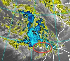
| Satelite image @ 6am, with 'Funktop' enhancemnt (Canaries in red oval) |
The day is starting completely overcast and after a calm night the wind is slowly increasing and turning gusty.
All emergency services in the Canary Islands have been put on standby and the authorities have asked the population and visitors to remain indoors and not to travel unless absolutely necessary. They're also advising to take the maximum care and all possible precautionary measures.
+8th UPDATE, Sunday 03/03/13 @ 10:30am:
The latest wind warnings by AEMET have increased maximum winds speeds to 120 km/h - that is Bf hurricane force 12 - for gusts in exposed areas in the western islands.
The storm system is moving in from the West and so the Eastern Canary Islands will be affected last and (hopefully) to a lesser degree.
If you have to travel later today or tomorrow, do be extremely careful and allow extra time. My personal opinion is that all traffic by road, sea and air could be severely disrupted from later today until Tuesday - and especially tomorrow, Monday March 4th. Expect cancellations and check with the operators of whatever service you're planning to use.
+9th UPDATE, Sunday 03/03/13 @ 4:30 pm:
The government of the Canary Islands has declared the highest alert level (ALERTA MAXIMA) for the western Canaries and for Gran Canaria. They now expect winds gusting well above hurricane force 12 Bf with speeds possibly exceeding 130 km/h in places.
A press conference is expected to be held shortly.
It certainly is gradually getting worse by the hour and I'm just back from securing everything I could around two presently vacant neighbouring houses as well. It looks like tonight is going to be a long sleepless night. I just hope the power supply and the phone lines will hold. If you don't hear from me every now and again you'll know that they didn't hold.I'll give you details of the press conference later...
+10th UPDATE, Sunday 03/03/13 @ 6:30 pm:
Not much new at the press conference. I've already reported all the relevant information in my previous updates. The only news was that all schools and universities in La Gomera, La Palma, El Hierro, Tenerife and Gran Canaria (all the islands that will bear the initial brunt of the storm) will remain closed tomorrow.
Some minor incidents and traffic disruptions have already been reported from western islands.
The winds here in Valle Gran Rey on La Gomera have risen to a gale by now and the barometer keeps falling rapidly. The sea is very angry-looking and it is beginning to rain lightly. There was heavy rain in La Palma already and more than 100 mm have been reported at one station there.
+11th UPDATE, Sunday 03/03/13 @ 9 pm:
There are reports of road closures in the western Canaries and the last ferries to leave La Gomera were unable to berth in the port of Los Cristianos on Tenerife due to the strong wind and some waves coming in over the harbour wall. They will probably now continue to Santa Cruz de Tenerife. The Fred. Olsen ferry to La Palma was unable to dock there and is now going back to Tenerife. My guess is that there won't be ANY sailings anywhere in the Canaries tomorrow, but DO check with your ferry company. Some flights in the second half of today were cancelled or diverted, but most did operate.
There was some flooding on La Palma and very strong winds up to 140 km/h and an articulated truck was overturned by the storm.
Reports of thunderstorms, heavy rain and winds well over 100 km/h are coming in from Tenerife and parts of Gran Canaria.
Here in Valle Gran Rey on La Gomera some stretches of road have been closed due to flooding of the barranco, as it has been raining continuously for a good while now, and some of that rain has been extremely heavy, accompanied by strong gusts of wind. As I write the rain is stopping, however.
Rockfalls and landslides have caused road closures and traffic restrictions in several locations in the western islands.
Ah yes, the Canarian meteorological association have named the storm 'Arteara' (after a place on Gran Canaria). It is their third named storm this winter season and the most vicious by far.
... and they say Arteara's worst wind is yet to come.
+12th UPDATE Monday 04/03/13 @ 1 am:
![]() |
| GFS forecast model for 12 noon Monday, March 4th '13, (Canaries in red oval) |
There were many minor incidents, small scale power cuts, localised flooding and blocked stretches of road reported from around the archipelago. On the island of El Hierro a several hundred year old dragon tree (an emblematic tree in the Canaries) sadly was felled by the gales.
Madeira has also been severely affected by the storm as has Morocco.
After a couple of hours of relative calm in Valle Gran Rey on La Gomera the wind is beginning to increase again and has backed SW...
+13th UPDATE, Monday 04/03/13 @ 3:30 am:
![]() |
| Significant wave height in metres for noon,Tuesday March 5th '13 (OPC) Tenerife is shown in the red circle |
Anyway the wind is rising rapidly again, the barometer is falling rapidly again and a short shower of rain is lashing not down, but sideways again !
The highest wind gust last night was recorded in Valverde, on El Hierro, by the official AEMET station, clocking a whopping 154 km/h (that's 96 mp/h to you, or 83 knots to me) ! Tenerife got the second-strogest gust at Izaña (140 km/h), 3rd place went to Gran Canaria (Tejeda,131 km/h) and La Gomera came fourth with 125 km/h recorded at Alto de Igualero, followed with just 1km/h less by the airport of La Palma - all well over the starting line for hurricane force.
The main worry over the next 18 hours should be the wind, and over the coming 36 hrs it's the significant wave height, which is increasing gradually with wind over a heavy swell.
+14th UPDATE, Monday 04/03/13 @ 8 am:
No change - ALL WARNINGS REMAIN 'IN FORCE' FOR TODAY.
![]() |
| Image taken a few minutes ago, with waves in front of Hotel Gran Rey on La Gomera. Wave height is expected to increase significantly until tomorrow. |
+15th UPDATE, Monday 04/03/13 @ 9 am:
AEMET, the Spanish met. office have now issued their highest (RED) alert, as well as the Canarian ACM, for all of La Gomera and El Hierro plus for the mountains of Tenerife, La Palma and Gran Canaria.
Winds exceeding speeds of 130 km/h in gusts can be expected there and the danger is IMMINENT, but more likely from around 11am.
Lesser, but still very significant danger exists in all other regions of the Canary Islands and further alerts for more areas may be issued later.
For detailed information go to the AEMET website by clicking the following link:
http://www.aemet.es/en/eltiempo/prediccion/avisos?w=hoy&k=coo&datos=img
+16th UPDATE, Monday 04/03/13 @ 1 pm:
At about 11:30am we had an extremely heavy squally shower that caused waterfalls in the steep mountainsides in Valle Gran Rey - and the electricity went until short while ago. The blustery squall itself didn't last too long, but as I write the next one is approaching rapidly. The temperature has dropped considerably with the first one and that means that the cold front associated with the storm depression is near or on us. It is a similar situation all over the Canaries and the coming hours should be interesting...
The only ferry now connecting La Gomera to the outside world is the ship of the Armas line that is sailing from Santa Cruz de Tenerife (instead of Los Cristianos) at the moment in the hope of berthing in San Sebastian de La Gomera and then attempting the return to Tenerife - weather permitting, that is ! The Fred. Olsen line have said that sailings are 'hardly probable' which I interpret as 'forget it'.
As I was writing the last words, the latest squall knocked out the power again for 10 mins. so I'll better finish this quickly.
All over the Canaries now: Traffic (sea, air, road) disruption - but not too bad. Lots of minor incidents and accidents. A larger landslide/ rockfall blocking the minor road to two small villages here on La Gomera.
BUT THANKFULLY THERE WERE NO REPORTS OF CASUALTIES UP TO NOW.
ALL WARNINGS REMAIN UNTIL BEING REVISED.
+17th UPDATE, Monday 04/03/13 @ 4:30 pm:
...well unfortunately we now have a casualty here in Valle Gran Rey. One person was very seriously injured by a rockfall. I won't say any more - ONLY TO STRESS AGAIN THAT IT IS EXTREMELY DANGEROUS TO BE OUT AND ABOUT IN THIS WEATHER. Don't be deceived by short periods of sunshine and slacker winds. Only venture out when necessary and then with extreme caution.
Since my last post it has been raining almost continuously, interspersed with very heavy squalls with fierce gusts of wind and, of course, power outages of various duration. The barranco, a normally dry riverbed, is like a river in spate now. The weather is still worsening and the waves are getting larger and more organised all the time.
Police and ambulances are racing with sirens blaring again just now, but I don't know what happened.
The MAXIMUM ALERT declared by the government has been extended to !!!!!!!!!!!! ALL CANARY ISLANDS now.
![]() |
| Huge area of thunderstorms very close to Canaries now |
+18th UPDATE, Monday 04/03/13 @ 7 pm:
![]() |
| OPC chart promising better weather in Canary Islands (in red oval) for Wednesday, March 6th 2013 |
However, warnings and alerts will remain in effect for tomorrow, Tuesday 5th of March (albeit downgraded a bit).
Wind, waves and occasional squally showers may still reach dangerous levels in the first half of tomorrow.
+The previous warnings for tonight remain ! There is the additional risk of thunderstorms, which could strike anywhere in the archipelago tonight.
The Fred Olsen ferry company has cancelled all sailings today until further notice and the planned sailing tonight by Armas from Gomera to Tenerife has been cancelled, as have many inter island flights. This situation will be revised tomorrow. As I write another severe squall is buffeting the house and a thunderstorm is lurking just west.
+19th UPDATE, Monday 04/03/13 @ 10 pm:
Sadly the casualty mentioned in my 17th update has now died of her severe injuries at the university hospital on Tenerife. She was a 26 year old German tourist who had been walking along a dirt track below a very tall sheer cliff leading from the harbour of Valle Gran Rey to a remote place called Argaga, when she was struck by falling rocks. She was rescued promptly by two different units of the emergency services and transferred later by helicopter-ambulance to Tenerife - all in atrocious weather conditions. She is the only fatality during storm 'Arteara' in the Canary Islands.
Meanwhile 'Arteara' shows no signs of easing at all and is still roaring wildly.
I'll leave it at that for today.
+20th UPDATE, Tuesday 05/03/13 @ 9 am:
Gust (km/h)
|
|||||
Station
|
Province
|
Hour
|
km/h
|
||
Tenerife
|
00:10
|
174
|
|||
El Hierro
|
14:10
|
140
|
|||
La Gomera
|
00:20
|
131
|
|||
Gran Canaria
|
13:20
|
121
|
|||
Tenerife
|
15:30
|
121
|
|||
Last night the storm peaked with severe gusts reported everywhere in the Canary Islands. As you can see above, the AEMET stations recorded a 131 km/h near Igualero on La Gomera yesterday, less than 15 miles from where I live and last night gust they recorded nearly the same. There were heavy downpours of rain in many locations as well and some thunderstorms. It certainly was the peak of the storm where I live in Valle Gran Rey and my house was pummelled all night by severe gusts and repeatedly very heavy showers pelted the roof.
All in all the Canary Islands escaped relatively unharmed after being battered by a very rare continuous storm that lasted more than 50 hours.
Schools and colleges have re-opened today
Warnings and alerts will remain in effect for today, Tuesday 5th of March 2013 until further notice.
At the moment winds are still strong and gusty, but decreasing, and the heavy swell is still causing problems for maritime traffic. Hundreds of people are stranded in the port of Los Cristianos on Tenerife because ferries were unable to berth. The Armas ferry that tied up in the port of San Sebastian de la Gomera yesterday was forced to leave for Santa Cruz de Tenerife during the night due to heavy seas entering the harbour. Several stretches of coastal roads have been closed, e.g. here in V.G.R. the stretch between La Playa and La Puntilla, due to waves breaking over the protective wall.
THE OUTLOOK:
Conditions should improve substantially later in the day as winds will gradually ease and the squally showers will become less frequent. The heavy swell at sea will slowly decrease from tonight. Lots of sunny spells, too. I expect warnings and alerts to be lifted later in the day, but please remain cautious today.
High tide is around 7pm tonight in the Canaries.
Tomorrow should see a return to more 'normal' Canary Islands weather.
+News just in: Fred. Olsen ferries will resume all sailings.
To La Gomera the following revised timetable applies today only (delays are possible, though):
Gomera - Cristianos 12:00 Horas
Gomera - Cristianos 17:30 Horas
Conditions are gradually improving, but during the occasional squalls it is still quite wild. News just in: There have been several larger rockfalls and/or mudslides on La Gomera, forcing the temporary closure of some stretches of road (e.g. Alajero - Pajarito and the road to El Rejo between the junction near Agando and the branch-off to El Cedro). Crews are out clearing the debris and it is hoped that these roads will reopen later today.
![]() |
| Storm in Canary Islands, March 5th, 2013 |
22nd UPDATE, Tuesday 05/03/13 @ 10:30 pm:
THE STORM IS OVER!!!
Back to normal tomorrow with CAUTION after a rare event. REMAIN VIGILANT TONIGHT AND TOMORROW MORNING!
+++++ SOME MORE WEATHER CHARTS:
![]() |
| OPC Chart for Tuesday March 5th showing the 'retreat' of the lows and building high pressure to the South of the Canary Islands |
![]() |
| OPC chart valid noon Sunday showing storm and new low forming |
![]() |
| NOAA chart for Saturday night, March 2nd '13 |
![]() |
| NOAA chart for noon on Monday, March 4th, 2013 |
![]() |
| Significant wave height for Tues. March 5th at noon.The small red arrow points to La Gomera and Tenerife being on the 6 metre line. |


.jpg)